Council's Strategic PlanConclude Flood Mitigation Infrastructure Investments (DV6) |
||
Stage 1Original reaches as identified within the 2014 Flood Mitigation Program. |
Stage 2Post 2020 Flood event modifications and program expansion. |
Stage 3Mitigation Integrity Review and additional work as identified. |
Organizational AdoptionProtection of the investment |
||
Flood Mitigation
The Municipality has a long history of flooding, with 17 major floods recorded since 1835. Sixteen of these were caused by ice jams. Because of this history, reducing the risks and impacts of flooding – called flood mitigation – has been a major priority for Council and residents.
Flood Mitigation Program
Council approved a permanent, structural Flood Mitigation Program to help protect the community. This program is a significant investment for the region and involves many complex decisions.
Different parts of the program are at different stages, with full completion expected in 2028. Once the permanent measures are in place, the program will shift to ongoing operations and maintenance.
Seasonal and Interim Measures
While permanent structures are being built, the Municipality continues to use seasonal and temporary flood protection measures. These plans are updated and improved each year based on lessons learned. As permanent measures are finished, fewer temporary measures will be needed.
Flood Mitigation Construction Updates for 2025
Reach Overview
A reach is a section or segment of land or riverbank that is included in the flood mitigation program. The program is divided into reaches so design, construction and monitoring can be managed in smaller, more practical parts.
It is important to understand the different levels referenced in these reaches.
- A 1-in-100-years flood (1% chance of happening in any given year) level is 250.0 metres above sea level.
- The 1-in-200-years flood (0.5% chance of happening in any given year) level is 250.4 metres above sea level.
The Municipality is building flood protection slightly higher than the predicted flood levels with an extra safety buffer of 0.5 metres. So, the 1-in-100-years flood level and the 1-in-200 years flood level is 250.5 metres and 250.9 metres respectively.
Map of Flood Mitigation Reach-by-Reach
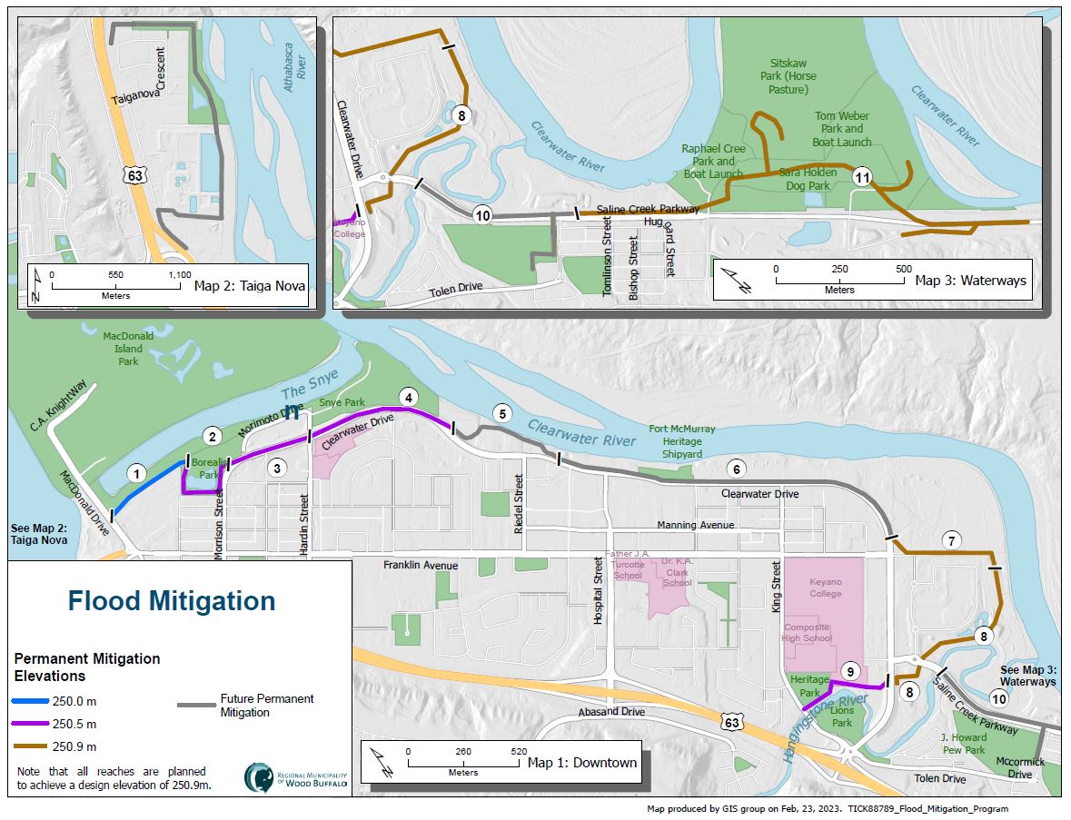
It is important to understand the different levels being talked about during the design and construction of these reaches. For clarification, the 1-in-100-years flood level is 250.0 metres above sea level and the 1-in-200-years flood level is 250.4 metres. above sea level. A freeboard of 0.5 metres is being added to both levels making the 1-in-100-years flood level and the 1-in-200-years flood level 250.5 metres and 250.9 metres respectively.
Reach 1: MacDonald Drive to Borealis Park
Status
Reach 1 was built to the 1:100-year flood elevation. Work to enhance existing mitigation to the 1:200-year flood elevation is expected to be completed in 2025.
Reach 2: Borealis Park to Morrison Street
Status
Reach 2 was built to the 1:100-year flood elevation. Work to enhance existing mitigation to the 1:200-year flood elevation is expected to be completed in 2025.
Reach 3: Morrison Street to Hardin Street
Status
Reach 3 was initially built to the 1:100-year flood elevation. Work to enhance existing mitigation to the 1:200-year flood elevation was completed in 2024
Reach 4: Hardin Street to McLeod Street
Status
Reach 4 was built to the 1:100-year flood elevation. Work to enhance existing mitigation to the 1:200-year flood elevation will proceed once higher priority flood mitigation projects are underway.
Reach 5: Wrapping around Edgewater Court and Riverwalk Villas
Status
Construction continues on Reach 5, with the structural mitigation completed to the 1:200 year flood elevation. Landscaping, trail paving and the installation of a gazebo overlooking the Clearwater River is expected to be completed by the end of the construction season 2025.
Reach 6: Riedel Street to Longboat Landing
Status
An interim clay berm was constructed along most of the Reach 6 alignment in 2020. This interim berm will remain in place until construction starts on the permanent mitigation. This berm continues to be monitored and inspected on an annual basis to ensure that a protection level of 250.0m is achieved.
In September 2024, Council approved Administration’s recommendations for the construction of Reach 6. This marks a key milestone in finalizing permanent flood mitigation for downtown Fort McMurray. It is anticipated that construction will begin in 2025 for structural mitigation to be placed between Clearwater Drive and the Clearwater River.
Reach 7: North Longboat Landing
Status
The structural clay berm for this portion of flood mitigation is 100% complete and has been constructed to the 1:200-year flood elevation. Due to public engagement feedback and trail alignment as a component of nearby waterfront connectivity, there are no plans to construct a trail in the Reach 7 area at this time
Reach 8: East Longboat Landing and Mills Avenue Booster Station
Status
Flood mitigation has been achieved to the 1:200-year flood elevation.
Status
Reach 9 is currently built to the 1:100-year flood elevation. Work to enhance Reach 9 to the 1:200 year flood elevation is expected to be completed in 2025.
Status
An interim berm was constructed in Fall 2020 along the Reach 10 alignment and was built to the 1:100-year flood elevation (excluding freeboard). This interim berm along the Reach 10 alignment will remain until the permanent structural mitigation measures have been completed.
Reach 10 flood mitigation has been divided into two scopes of work: Contract 1, to replace an existing retaining wall, and Contract 2, to raise a portion of Saline Creek Parkway, build limited earthworks in J. Howard Pew Park and connect to Reach 11.
Construction on Contract 1 began in May 2023, and is expected to be completed in late 2024, and Contract 2 is expected to begin in 2025.
Reach 11: Saline Creek Drive to Waterways
Status
Reach 11 construction is complete. Saline Creek Parkway re-opened in August 2023, and the new Sara Holden Dog Park, constructed as part of the project, opened in fall 2022.
Status
Construction is currently underway and anticipated to finish in 2025. The interim berm previously constructed for TaigaNova North will be gradually removed as construction progresses.
Status
Permanent flood mitigation at TaigaNova South is in the pre-design phase to block known flood pathways located south of the Wastewater Treatment Plant. C Design is anticipated to be finalized in 2025 with construction to begin in 2026.
Temporary flood mitigation measures will be used until permanent mitigation is in place to the 1:200-year flood elevation (250.9m).
Status
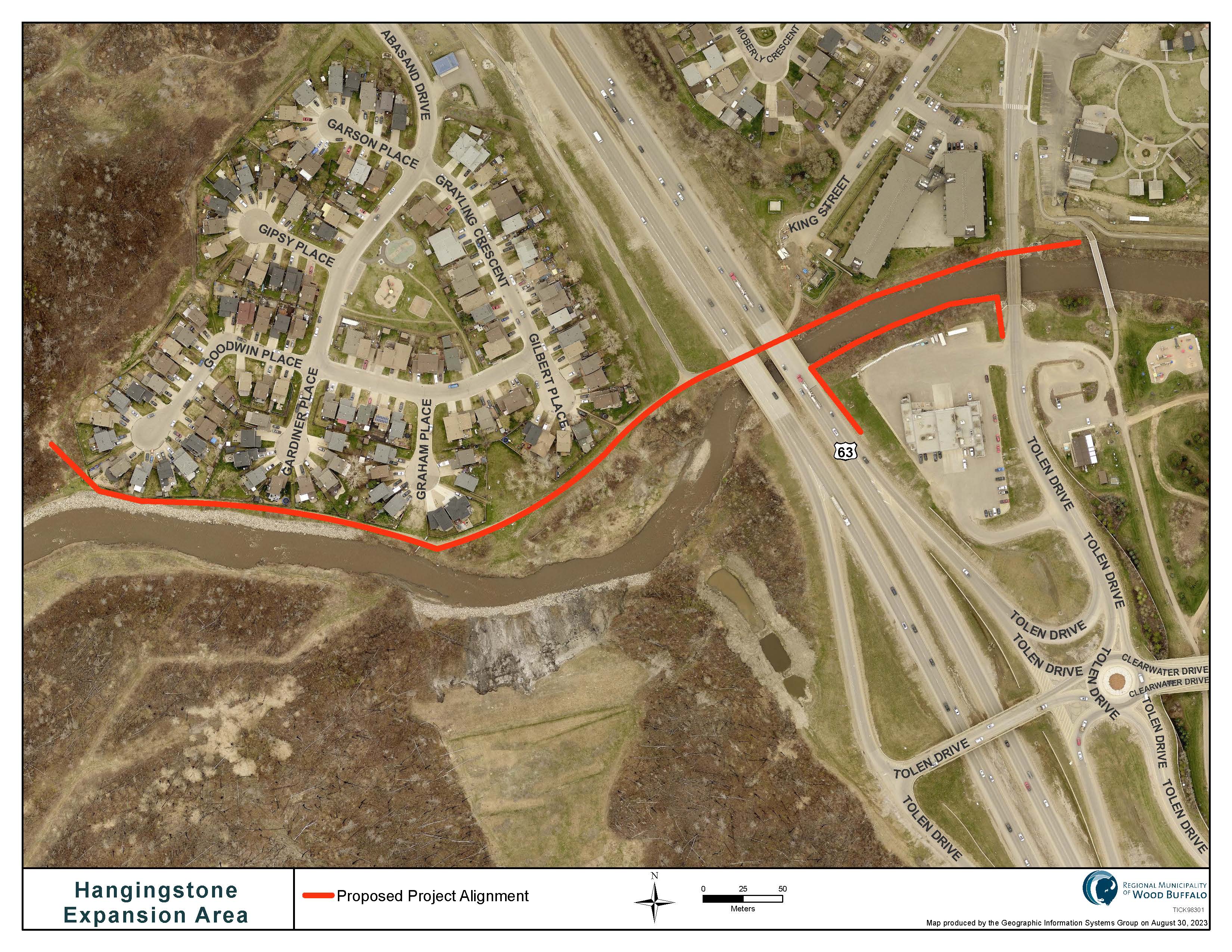
Due to the high-water event that occurred on June 15, 2023, a higher priority will be placed on completing permanent flood mitigation in the Hangingstone Expansion Area than was originally planned. An in-depth study will be completed to confirm the design and scope of the project with construction anticipated to begin in 2026.
Status
The Miscellaneous Underground Enhancements project is a multi-year, multi-area project to rehabilitate and upgrade storm infrastructure within the downtown Fort McMurray area. The purpose of this project is to improve the ability of the RMWB to react to differing high water level events, as well as replace and optimize aging assets. Construction has begun and is anticipated to be completed in 2025.
Resources
- 24-hour Mental Health Help Line - 1-877-303-2642
- Guide to Flood Recovery from the Canadian Red Cross
- Participate Wood Buffalo
Subscribe for RMWB updates
Stay up to date on the services, programs and projects in your neighbourhood!